Orissa Map District
Click here to View & Download Odisha map
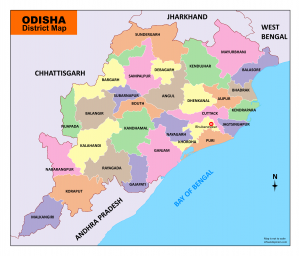
Odisha Map – You can download the map of Odisha as a PDF for free. You can use this map for educational and non-commercial purposes.
Odisha (Orissa) is one of the 29 states of India. The state is located on the eastern coast of India. Orissa is surrounded by the states of West Bengal, Jharkhand, Chhattisgarh, and Andhra Pradesh. Odisha has 485 kilometers of coastline along the Bay of Bengal on its east. Odisha is the eighth largest state by area and the 11th largest by population.
Odia (Oriya) language is the official and most spoken language of the state.
Bhubaneswar is the capital city of Modish. It is located in Khordha district.
Orissa is divided into 30 districts under 3 revenue divisions.
Mayurbhanj is the largest district, and Jagatsinghpur is the smallest district by area. According to the population, Ganjam is the largest district and Deogarh is the smallest district in Odisha.
Download Odisha map
List of Districts & Revenue divisions in Odisha.
| Divisions | Districts | Headquarters | Population | Area |
| Cuttack | Cuttack | Cuttack | 2,624,470 | 3,932 |
| Jagatsinghpur | Jagatsinghapur | 1,136,971 | 1,668 | |
| Kendrapara | Kendrapara | 1,440,361 | 2,644 | |
| Jajpur | Jajpur | 1,827,192 | 2,899 | |
| Puri | Puri | 1,698,730 | 3,479 | |
| Khordha | Khordha | 2,251,673 | 2,813 | |
| Nayagarh | Nayagarh | 962,789 | 3,890 | |
| Balasore | Balasore | 2,320,529 | 3,806 | |
| Bhadrak | Bhadrak | 1,506,522 | 2,505 | |
| Mayurbhanj | Baripada | 2,519,738 | 10,418 | |
| Sambalpur | Sambalpur | Sambalpur | 1,041,099 | 6,624 |
| Bargarh | Bargarh | 1,481,255 | 5,837 | |
| Jharsuguda | Jharsuguda | 579,505 | 2,114 | |
| Deogarh | Deogarh | 312,520 | 2,940 | |
| Balangir | Balangir | 1,648,997 | 6,575 | |
| Subarnapur (Sonepur) | Sonepur | 610,183 | 2,337 | |
| Dhenkanal | Dhenkanal | 1,192,811 | 4,452 | |
| Angul | Angul | 1,273,821 | 6,376 | |
| Keonjhar | Keonjhar | 1,801,733 | 8,303 | |
| Sundargarh | Sundargarh | 9,712 | ||
| Berthampur | Ganjam | Chhatrapur | 3,529,031 | 8,206 |
| Gajapati | Paralakhemundi | 577,817 | 4,325 | |
| Kandhamal | Phulbani | 733,110 | 8,021 | |
| Boudh | Boudh | 441,162 | 3,098 | |
| Kalahandi | Bhawanipatna | 1,576,869 | 7,920 | |
| Nuapada | Nuapada | 610,382 | 3,852 | |
| Koraput | Koraput | 1,379,647 | 8,807 | |
| Rayagada | Rayagada | 967,911 | 7,073 | |
| Nabarangpur | Nabarangapur | 1,220,946 | 5,291 | |
| Malkangiri | Malkangiri | 613,192 | 5,791 |
Mr Jeeten Shivani
Iloveyoumyindiacountry