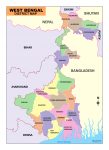
West Bengal map – You can download the map of West Bengal as a PDF for free. You can use this map for educational and non-commercial purposes.
View & Download the West Bengal map
West Bengal
West Bengal, the fourth most populous state of India, is located in the eastern region of India along the Bay of Bengal. The total land area of West Bengal is 88,752 km2 (34,267 sq mi).
The state’s land borders touch Bangladesh in the east and are
separated from Nepal in the west, Bhutan lies to the north-east, while Sikkim is to the north. The state of Bihar and Jharkhand to the west, while Odisha is to the south, and the Bay of Bengal protects its southern borders.
West Bengal is divided into 23 districts under 5 administrative divisions.
The names of the divisions are Malda, Burdwan, Jalpaiguri, Presidency, Midnapur.
West Bengal Map Outline
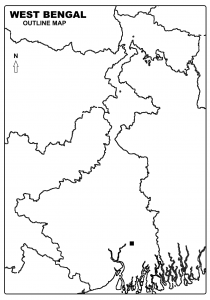
View & Download the West Bengal Outline map
View &Download the List of Districts in West Bengal
Name of the District of West Bengal
| Sl no. | District |
| 1 | Alipurduar |
| 2 | Bankura |
| 3 | Paschim Bardhaman |
| 4 | Purba Bardhaman |
| 5 | Birbhum |
| 6 | Cooch Behar |
| 7 | Darjeeling |
| 8 | Uttar Dinajpur |
| 9 | Dakshin Dinajpur |
| 10 | Hooghly |
| 11 | Howrah |
| 12 | Jalpaiguri |
| 13 | Jhargram |
| 14 | Kolkata |
| 15 | Kalimpong |
| 16 | Malda |
| 17 | Paschim Medinipur |
| 18 | Purba Medinipur |
| 19 | Murshidabad |
| 20 | Nadia |
| 21 | North 24 Parganas |
| 22 | South 24 Parganas |
| 23 | Purulia |
Download West Bengal map
Sir,
I want to start a youtube channel for educational purpose. I wanted to use this map for my videos if you allow me. Thanks in advance.
Thanks and regards
Sudipta Das Roy
Feel free to use it. Best wishes for your channel
Dear sir,
Please required west Bengal and north east map with village please send me samples.
Thanks & Regards
Pradeep Sharma
9153731376/8768132600